NARBO
- Top
- Database Top
- 1.Event
- The 5th Training Program
- Day 6
- SEA workshop
|
|
|
Partnership Building : A Key to successful Implementation of IWRM Programin the Laguna de Bay Region |
|
Amidst the development of technologies geared towards successful implementation of integrated water resource management program, the active involvement and participation of the stakeholder groups remain to be the major factor that IWRM practitioners should look deeply into.
|
|
Important Features of Laguna de Bay |
|
Laguna de Bay or popularly known as Laguna Lake, is located at the center of the country’s key agro-industrial development zone – also known as the CALABARZON. With a surface area of 900 km2 (90,000 hectares) and a shoreline of 285 km, it is considered as the largest fresh water lake in the Philippines and one of the largest in South East Asia. The 2,290 km2 watershed area cover sixty-six (66) Municipalities from five (5) provinces and the highly urbanized Metro Manila area. To date more than 10 million people live within the watershed area that directly or indirectly affect the general condition of the lake.
|
|
Uses of the Lake |
|
For a long time, the lake is used predominantly for aquaculture purposes. Commercial and subsistence fishing (for small fisherfolks) are common sights the whole year round. However, thru time other uses have been identified catering to the needs and activities of the various stakeholder groups in the region. The lake is used for cooling purposes by the industries around the lake. On the other hand, farmers utilize the lake for irrigation and also for recreation purposes. The CBK Power Co., Ltd, a hydro power company, uses the water from the lake to operate its plant. It is also used as a transport route by local merchants and ferry operators.
|
|
 |
|
Picture 3. Water Resources Potential
|
|
Task of PJT Ⅱ is to manage output of the development, the government established a Public Corporation in 1970 named "Jatiluhur Authority" Public Corporation. Since 1999, it was changed to "Jasa Tirta Ⅱ"Public Corporation to recognize the entity with the core of business in water. The dam has been achieving valuable benefits that became commitment to prevent the existence. Further development in Citarum River, upstream Ir. H. Djuanda Dam were the construction of Saguling (1984) and Cirata dams (1988). The purpose of the dams is mainly for generating hydropower electricity with the installed capacity in Saguling and Cirata are 700 MW and 1000 MW respectively. The dams and the power stations were constructed and being operated by the National State Electric Company.
|
|
In line with the Government Regulation of the Republic Indonesia No. 94 year 1999 dated October 1999 and the.Decree of Minister of Resettlement & Regional Infrastructures No.18/KPTS/M/2000 dated 15 December 2000, about the guidelines of operational activities of PJT Ⅱ, the tasks are as follow : |
|
|
|
PJT Ⅱ vision is to realize a well known and high quality company in water management and water resources for wide service in water supply to the various requirement and contributions to national food sufficiency.
|
|
Mission to realize the Corporation Vision, the company has Missions as follows (1) Raw water supply for drinking water, electric generation, agriculture, industry, harbor, flushing and other need (2) Electric power generation and supply the electric power (3) To develop Tourism and land use, (4) To maintain the food sufficiency by mean supplying of agriculture water and flood control with effort of preservation environment protection by mean information, recommendation and guidance (5) To maximize the profit and to foster the benefit based on business principle in assuring government asset continuance and service continuity to public.
|
|
In general, water is a natural resource needed by all creatures in the globe and no other substance substitute. Comprehensive water resources management in Citarum river basin includes:
|
|
|
|
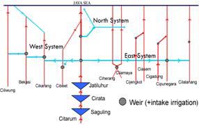
Citarum System |
|
Citarum river is biggest one connected with four rivers to the West namely Cibeet, Cikarang, Bekasi and Ciliwung and four rivers to the East namely Ciherang, Cilamaya,Ciasem and Cipunegara by man made canals namely West Tarum Canal and East Tarum Canal respectively formed a unit by hydrological boundary of Citarum integrated basin of 12.000 km2.
|
|
| Three big reservoirs, in the upstream, Saguling, Cirata and Djuanda Reservoir regulates river run off and releases stable water flows to the curug barrage and diverted to the west Tarum Canal and east tarum canal by gravitation to the north. | |
|
|
Picture 4. Citarum Water Resources Configuration |
|
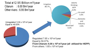
After the construction of Djuanda Dam and reservoir the systems were integrated and become Jatiluhur Irrigation System. The water released from Djuanda Reservoir through turbines to generate electric power, besides through other means named hollow-jet valves and then flows to Citarum down-stream. About 8 (eight) km from the tail race, the water were diverted to the West and to the East and discharged into West Tarum Main Canal and East Tarum Main Canal respectively. Citarum through operation of Djuanda Reservoir became the water main source especially during dry season. In principle during wet season, 70% water requirement could be supplied by local resources and 30% from Djuanda Reservoir, while during the dry season, it only 30% of the requirement could be provided by local resources and the rest of 70% are supplied from the reservoir. |
|
Citarum Water System of 240,000 ha were divided into 3 services area namely West Irrigation System (57.000 ha), North Irrigation System (81.000 ha) and East Irrigation System (102.000 ha). The three systems were operated and maintained by Division I, Division II and Division III respectively. Operation and maintenance of Djuanda Dam and Reservoir including Hydro Electric Power Station under the responsibility of Division IV on the other way the watershed are obligated in to Division Citarum Hulu.
|
|
| Water Operation | |
Based on the law No. 7 on year 2004 concerning Water Resources and utilization are as follows : first is for domestics and municipalities, second is for agricultures including fisheries and animal, third is for industries, and the latter is for power generation. In order to be distributed equally to beneficiaries the Government established Water Resources Management Committee in the provincial level and Water Resources Management Implementation Committee in the basin level. The members of the committee are the representatives of the government institutions, private sectors, Non Government Organizations, universities, professionals, and representatives of farmer associations. In fact the members of the committee are representing of water regulators, basin operators and water users all together are the stakeholder. |
|
Irrigation is the biggest demand of water it is about 90% of the total demand for two crops per year. The first crop is commenced in the first of October or in the beginning of rainy season and the second crop is commenced in the first of April. For which the Committee extend the meeting at least twice a year, once every August for preparing annual water supply program considering the availability of water in the reservoirs and prospective weather in coming year, secondly every April for evaluation of the implementation program and/or analysis of the continuation of the program or preparing the program modification if necessary. |
|
According to the Note for Jatiluhur (Ir. H. Djuanda) Reservoir Operation (Angoedi, 1960) total water demand in the downstream of the reservoir will be supplied during wet season 70% from local resources and 30% from the reservoir, and conversely, during dry season 30% from local resources and 70% from the reservoir. The committee is also prepares integrated reservoirs operation rule curve based on the equal sharing of the three reservoirs in term of water level and hydro electric power production.
|
|
| Water Resources Quality | |
The national economic growth speed impacts on the decreasing of water resources quality. Water from its sources in the conservation (reservoirs or rivers) and its canal system almost has no buffer zones both in quantity and in quality. People who have no field for agricultural cultivation, settlement, and business area are very low in attention for natural resources preservation for further importance.
|
|
| The development without base principles and less care of site plan cause the imbalanced development by the environmental support, power, mainly Bandung Concave which is a river headstream. One of the worrying impacts is the decrease of the water quality and/ or water resources. There are three polluter resources on the quality of Citarum River, namely settlement, industries, and agriculture, cattle, and fishery. | |
 |
|
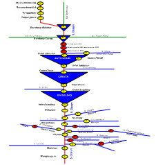
Picture 8. Monitor Point Location of Citarum Water Quality |
|
Coordination |
|
PJT Ⅱ as a state-owned company is mandated to manage the Citarum river basin. Its jurisdiction covers the whole project area from the watershed of the Citarum river down to the estuary including the main canals.
The Public Work Department of Republic Indonesia and West Java Governor and has the authority to approve public to use water in the project area. PJT Ⅱ is responsible for examining new applications to use water, especially concerning the effects on water availability trough demand and supply balance simulation, and to submits recommendations to Governor.
The annual allocation of water in the main river and canals is subject to the results of coordination by River Basin Water management executive committee (PPTPA). The Governor decides the annual allocations to various users in his decree, based on PPTPA recommendations. The first priority is for drinking water, the second to cultivation, the third to industry and the last to hydropower. Coordination among stakeholders in Citarum river basin is to coordinate water administrator, users and other stakeholders. PJT Ⅱ in managing the citarum shall be coordinate with : |
|
|
|
The evaluation of water allocation in Jasa Tirta II Public Corporation working area, executed:
|
|
|
|
The rule curve mentioned above is also prepared based on equal-sharing principle from those three reservoir.
|
|
| Issues and Challenges | |
Due to its location and its available resources, the Citarum river basin can play a major role in the development of the rapidly growing West Java Region, in which Jakarta and Bandung are the major center of economic activity. Considerable investment in infrastructure have already been made to support irrigation development, hydropower production, flood control, and domestic, municipal and industrial water supply. However, the expected socio-economic development of the region forms a considerable challenge for water management.
Issues to be faced in water resources management: |
|
|
|
Indonesia has issued the water law in 2004 with provides the enabling framework for IWRM. Implementation of IWRM within river basin context is being promoted through establishment of river basin management units or Balai / Balai Besar and also strengthened the existing corporate type organization (Jasa Tirta public corporation). |
|
Benchmarking |
|
In order to secure continual improvement, PJT II has opportunity to use the benchmarking tool. This benchmarking used the Balance-Score-Card to monitor and evaluate periodically the work and achievements of our corporation in implementing IWRM. In developing Annual Work Budget and Program PJT II has incorporated the IWRM philosophy into it beside last year Annual Work Budget and Program evaluation.
Since 1999, PJT II has adopted ISO 9001 for Quality System. The main goal of this system is customer satisfaction through continual improvement philosophy. Customer satisfaction is also a parameter for performance benchmarking. |
|
Conclusion |
|
| Keys to success in IWRM for our RBO: | |
|
|